Borders have shaped our world in ways most of us never stop to think about. Cities, states, provinces, and entire nations have been carved out, negotiated over, and sometimes fought over because of these invisible and not-so-invisible lines. Some borders are simple painted lines on a road. Others are roaring waterfalls, ancient stone walls, or a volleyball net stretched between two countries. And yes, one of them is literally a zipline.
Whether you find borders fascinating, frustrating, or somewhere in between, there is no denying that they tell some of the most compelling stories on the planet. The story of wars fought, peace treaties signed, rivers that decided the fate of nations, and communities that refused to let a political line get in the way of a good game of volleyball.
So buckle up. We are going on a global tour of the world’s most fascinating, bizarre, beautiful, and downright strange borders. A few of these will genuinely surprise you. At least one will make you laugh. And all of them will make you see the world a little differently.
Giant Fish, Volleyball Nets, and Ziplines: The World’s Most Fascinating Borders
The Giant Fish Marking the Poland and Ukraine Border
The Poland-Ukraine boundary stretches for 535 kilometers and separates two countries with a deeply intertwined and often turbulent history. The border traces its origins back to 1920, when the Treaty of Warsaw was signed following the Polish-Ukrainian War. Since then, it has shifted multiple times as the region’s political landscape changed around it.
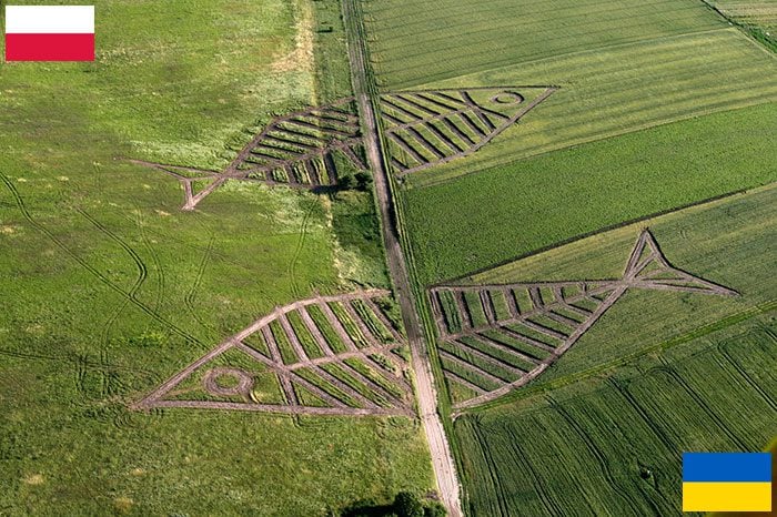
Along that 535-kilometer stretch, there are several interesting border markers. But none of them come close to this one. These enormous fish geoglyphs were created by Polish artist Jaroslaw Koziara, and they were designed specifically as a symbol of unity between the two nations. Not a wall. Not a fence. Giant artistic fish.
When you think about it, that says something rather beautiful about the relationship between Poland and Ukraine, at least in the creative sense. Art as a border marker is not something you see every day, and this one is absolutely worth knowing about.
Three Countries, One River Junction: The Triple Frontier of Argentina, Brazil, and Paraguay
South America has no shortage of dramatic geography, and nowhere is that more apparent than at the Triple Frontier. This is the point where Argentina, Brazil, and Paraguay all meet, and it is not a man-made marker that separates them. It is nature doing all the work.
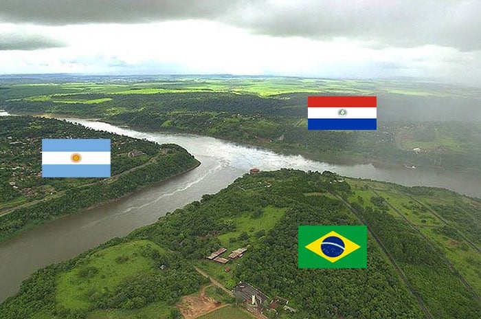
The Iguazú and Paraná rivers converge at this exact junction point, forming a natural boundary that splits three countries simultaneously. Each country has its own border city right at this meeting point, and the area sits close to the famous Itaipú hydroelectric dam, one of the largest in the world.
For tourists, this is a dream location. You can technically hop between three countries in the span of an afternoon. The Triple Frontier is a rare geographical formation that doubles as one of the more memorable travel experiences in South America.
Where Three Flags Stand Together: Germany, Poland, and Czechia in the Sudetes
This is the kind of scene that looks like it belongs on a postcard. The Eastern Upper Lusatia is a natural region that sits within the Western Sudetes area, and the Sudetes Mountain range is shared between Germany, Poland, and Czechia. Parts of the Lusatia stretch into all three countries, with a single tripoint where they all converge.
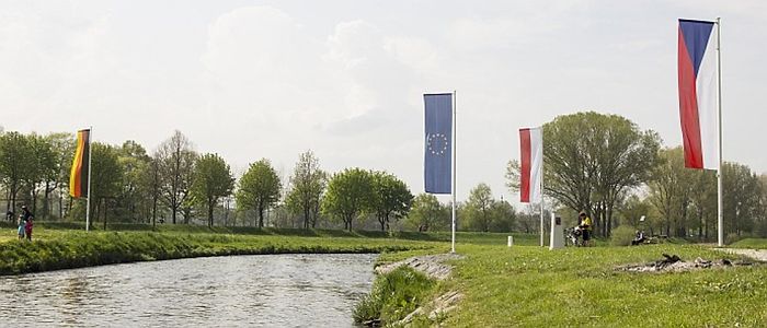
The picture captures this meeting point beautifully, with the flags of all three nations and the European Union planted side by side. There is something quietly powerful about standing at a spot where three nations share the same patch of ground without conflict or tension. Just flags in the wind.
Standing on the Line Between Two of Africa’s Greatest Parks: Kenya and Tanzania
The Maasai Mara National Reserve in Kenya is one of the most iconic wildlife destinations on the planet. Named after the Maasai people who settled in the region centuries ago, the reserve shares a boundary with Tanzania’s Serengeti National Park. In effect, these two parks function as the natural border between the two countries.
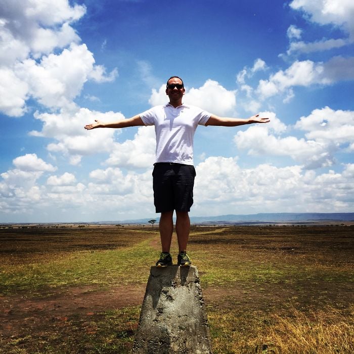
The photo shows a man standing on a stone marker that physically identifies the borderline between the two reserves. Not many people can say they have stood between two of Africa’s most celebrated wildlife parks at the same time. That is one border worth crossing for.
A 500-Meter Bridge Named After Royalty: Hungary and Slovakia
This is the Mária Valéria Bridge, and it is genuinely stunning. The bridge connects two central European cities: Esztergom in Hungary and Štúrovo in Slovakia. The two cities sit on opposite banks of the River Danube, Europe’s second-longest river, and this bridge is what brings them together.
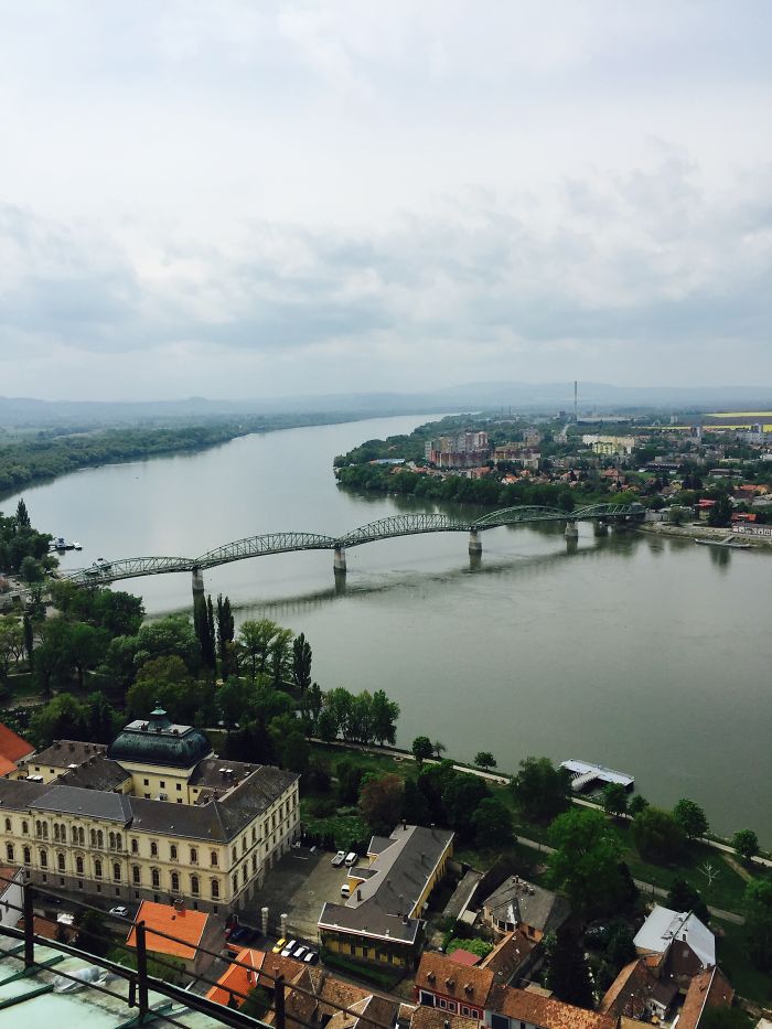
The bridge takes its name from Archduchess Marie Valerie, the daughter of Austrian-Hungarian Emperor Franz Josef and Duchess Elisabeth of Bavaria. At 500 meters long, it is an impressive structure, but its history is just as interesting as its architecture. This bridge represents a connection between two nations that share centuries of complex and intertwined history.
A Monument in the Middle of a River: France, Germany, and Switzerland at Basel
Basel is Switzerland’s third-largest city and one of its most culturally rich. It is known for world-class art museums, a prestigious education system, and architecture that genuinely earns the word beautiful. But tucked within the city, sitting right in the middle of the Rhine River, is something that makes Basel truly unique on a global scale.
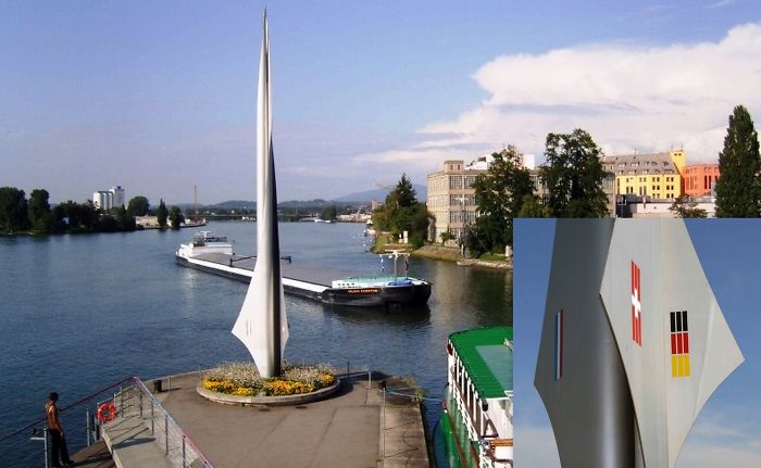
That something is the Dreiländereck monument. Planted on Swiss territory in the middle of the Rhine, this marker identifies the exact spot where the borders of Switzerland, France, and Germany all meet. Three countries, one river, one monument. It is the kind of geographic quirk that reminds you just how densely layered Europe really is.
The World’s Smallest Artificial Island: Finland, Norway, and Sweden’s Three-Country Cairn
At first glance, this looks like a random pile of stones sitting in the middle of water. But this stone structure, known as the Three-Country Cairn, is actually the tripoint where the Nordic nations of Finland, Norway, and Sweden all converge. Each country has its own name for it in their respective languages.
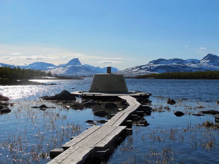
The cairn was built in 1926 after years of border changes and diplomatic negotiations between the three countries. Because it sits in water as an artificial island, it holds the distinction of being the smallest artificial island in the world. The use of cairns as border markers has been a longstanding tradition in the Nordic region, but this one takes the title for the most memorable.
The Ancient Wall That Once Divided Britain: Hadrian’s Wall
This one is not a border that is still in use today, but it would be a genuine shame to leave it out. Hadrian’s Wall is one of the most iconic structures in human history. Built in 122 AD by order of Roman Emperor Hadrian, this fortified defensive wall stretched horizontally across the British isle from coast to coast.
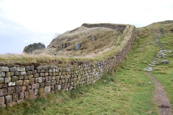
The purpose of the wall was to keep out the rebellious Caledonian tribes from the north. Caledonia, for those who were not aware, is the Latin name for Scotland. Nearly two thousand years of natural decay and large-scale stone looting have significantly reduced the wall’s original size, but what remains is still breathtaking. Walking along its remaining stretches gives you a tangible sense of just how determined the Romans were about keeping their boundaries intact.
The Hill That Almost Had Four Countries: Belgium, Germany, and The Netherlands at Vaalserberg
Near the Dutch town of Vaals, there is a hill and forested area called Vaalserberg. Until 2010, this hill had the distinction of being the highest point in the Netherlands. But that is not what makes it truly interesting.
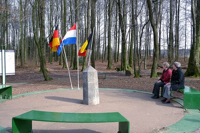
Here is the part that surprises most people: this tripoint almost became a quadripoint. Back in 1816, a territory called the Condominium of Neutral Moresnet existed right here, jointly administered by the kingdoms of the Netherlands and Prussia. That small strip of land could have given this hill a four-country meeting point. Instead, Neutral Moresnet became part of Belgium in 1920, and we are left with a very interesting tripoint and an even more interesting piece of forgotten history.
Nearly a Thousand Years Old and Still Standing: The Stripe Between Portugal and Spain
Not every border on this list is dramatic or visually striking. Some are remarkable simply because of their age. The border between Portugal and Spain, known as The Stripe (or A Raia in Portuguese and La Raya in Spanish), stretches over 1,200 kilometers. More impressively, it has been in place for close to a thousand years, making it one of the oldest continuously maintained borders in the world.
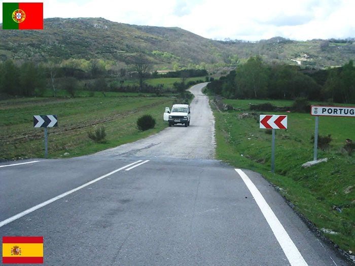
The shape of this border was first established in 1143, following Portugal’s victory at the Battle of Valdevez. It was then redefined in 1297 through the peace Treaty of Alcañices, and has remained largely unchanged ever since. Think about that for a moment. A border agreed upon in the 13th century is essentially still where it was placed over 700 years ago. That is a level of political stability that very few borders anywhere in the world can claim.
A Waterfall That Splits Two Countries: The Iguazu Falls Between Argentina and Brazil
The Iguazu Falls need little introduction, but the border context is something that often gets overlooked when people discuss them. Formed by the Iguazu River in South America, these falls serve as a natural border between the state of Paraná in Brazil and the province of Misiones in Argentina. Two countries, one waterfall, zero arguments about who gets the better view.
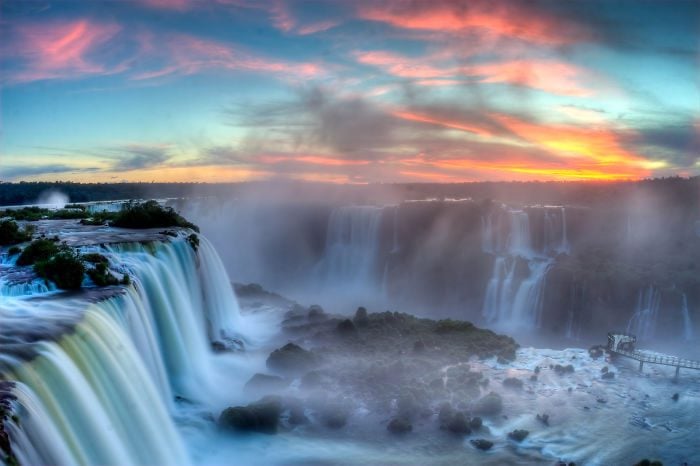
Beyond being one of the most visited natural wonders on the planet, Iguazu also made a cameo in the Marvel film Black Panther. The falls are shared between two national parks, one on each side of the border, and both are recognized as UNESCO World Heritage Sites. Not bad for a border marker.
What a Forest Tells You About a Country: Germany and Czechia’s Tree Line
This one is not about monuments or rivers. It is about trees, and what they reveal when you see them from above. This aerial photograph was taken along the border between Germany and the Czech Republic, near the Czech Šumava National Park, also known as the Bohemian Forest National Park.
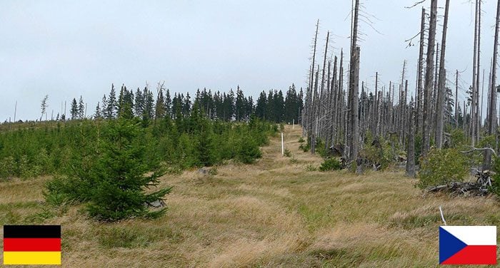
The difference is stark. The Czech side on the right shows the consequences of unmanaged bark beetle infestations. The bark beetle is widely considered a pest in the forestry and lumber industry because of the serious damage it does to trees. When left unchecked, the results look exactly like what you see in that image. One border, two different approaches to forest management, and a very clear visual lesson in environmental policy.
The Only Border in the World You Can Cross by Zipline: Spain to Portugal
Yes, you read that correctly. There is a zipline that takes you from Spain to Portugal. Not a bridge. Not a boat. A zipline. The ride runs from the Spanish city of Sanlucar de Guadiana, straight across the Guadiana River, and deposits you in Alcoutim, Portugal, on the other side.
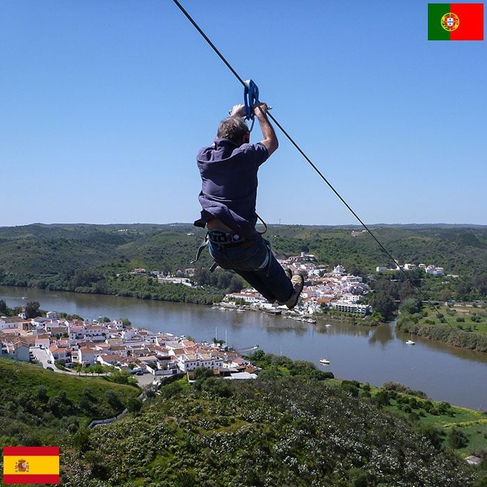
The Guadiana River, sometimes called the Odiana, is an international river that forms part of the famous Portugal-Spain border known as The Stripe. The zipline stretches 720 meters across the water, and at full speed, riders can hit 70 kilometers per hour. It is not exactly the most thorough border crossing process, but it is almost certainly the most fun one in existence.
An Engineering Marvel That Connects Two Kingdoms: The Øresund Bridge Between Denmark and Sweden
Before anything else: the flags in the famous photo of this bridge are on the wrong sides and should be reversed. That minor detail aside, the Øresund Bridge is one of Europe’s most remarkable feats of modern engineering. The bridge covers 8 kilometers and connects the kingdoms of Denmark and Sweden across the water.
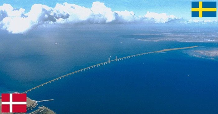
The bridge begins in Malmö, Sweden, and runs for 8 kilometers before connecting to an artificial island called Peberholm. From there, it transitions into the 4-kilometer Drogden Tunnel, which runs underwater to connect to the tiny island of Amager in Denmark. So technically, you are crossing the border by bridge and by underwater tunnel on the same journey. That is two modes of crossing for the price of one trip.
A Forest Line That Stretches for 1,630 Kilometers: Norway and Sweden
This is only a small section of the border between Norway and Sweden, but it gives you a good sense of just how vast and remote parts of it are. This particular stretch cuts through dense forest and a frosty, almost otherworldly landscape.

The full Norway-Sweden border runs for 1,630 kilometers and was established in 1814 following the Treaty of Kiel. For most of its history, crossing between the two countries was a relatively relaxed affair with minimal restrictions. That changed during the Covid-19 pandemic, when tighter border controls were introduced for the first time in a long while. The pandemic revealed just how much people on both sides had taken that open border for granted.
A Bridge That Is Literally the Border: Another View of Norway and Sweden
The forested stretch of the Norway-Sweden border is not the whole picture. Borders cross through landscapes of all kinds, including rivers and the bridges that span them. This image shows a bridge that forms part of the Svinesund road, with the border running directly through the middle of the bridge itself.
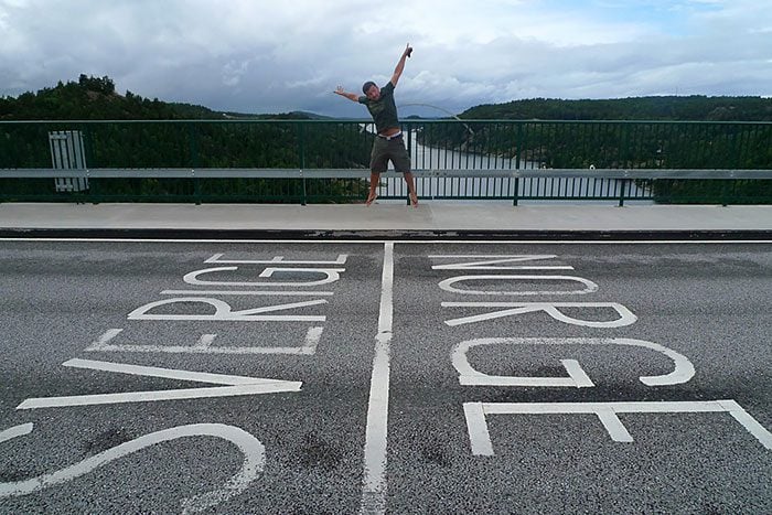
The border was established in 1814, at a time when Norway and Sweden were not just neighbors but actually part of a joint union together. The United Kingdoms of Sweden and Norway lasted from 1814 all the way to 1905, when Norway declared independence and crowned Haakon VII as its king. That bridge carries a lot more history than it might appear to at first glance.
One Island, Two Countries, One Beach: Poland and Germany at Usedom
Out in the Baltic Sea sits the sandy island of Usedom. At 66 kilometers long and 23 kilometers wide, it is a substantial island. What makes it unusual is that it is divided between two countries: Germany and Poland. Together, the two sides are home to a mixed population of around 76,000 people.
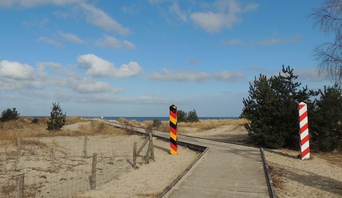
The German side is known for its distinctive resort architecture and three charming beachside towns. The Polish south is home to a two-century-old lighthouse and its own Museum of Sea Fishery. The island as a whole is celebrated for its natural parks. Sharing an island across national borders sounds complicated on paper, but Usedom pulls it off with a kind of relaxed elegance that is hard not to admire.
Where Mountains Are the Border: Austria and Slovenia Over the Alps
Not all borders are drawn with ink or negotiated over a table. Some are simply carved out by the land itself. The Karavanke mountain range, also called the Karawanken, runs between the Sava and Drava rivers in central Europe and forms a natural dividing line between Austria and Slovenia as part of the Southern Limestone Alps.
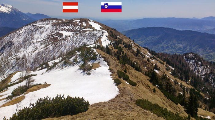
There are two main ways to cross this mountain border. The oldest route is the Wurzenpass, running between Carinthia in Austria and Podkoren in Slovenia. The more modern option is the Karawanks Motorway Tunnel, a transnational tunnel that opened in 1991. Either way, crossing this border means going through or over a mountain range. That is not something every traveler gets to say.
The River That Wiggles Between Two Countries: Romania and Moldova’s River Prut
In Eastern Europe, the Prut River winds its way southward before flowing into the Danube. Along the way, it serves as a natural border between Romania and Moldova, with parts of it also touching the boundary of Ukraine. From above, the river looks like it cannot quite make up its mind about which direction to go, snaking back and forth in broad, sweeping bends.
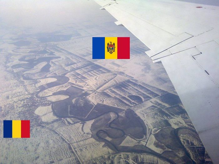
The aerial photograph gives you a striking view of just how dramatically the river bends between the two countries. As for the name, historians believe it either comes from the Ancient Greek word Pyretus or the Scythian name Porata. Either way, this river has been marking this corner of the world for a very long time.
The Friendship Bridge Between Brazil and Paraguay
Built in 1965, the Friendship Bridge stretches 290 meters across the Paraná River, connecting the Paraguayan city of Ciudad del Este with Brazil’s city of Foz do Iguaçu. It is not the longest or the flashiest bridge on this list, but it might be the most economically important one we will cover.
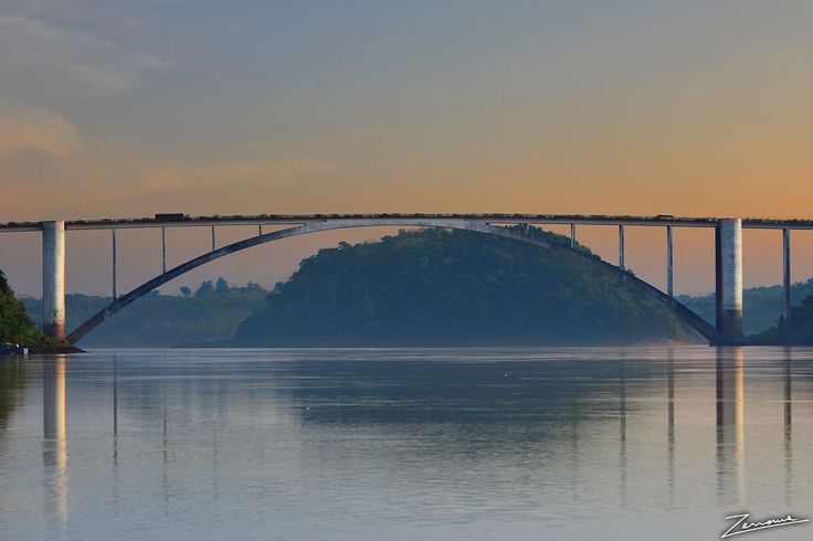
The bridge allows the cities on both sides to trade freely with each other, and the volume of commerce that crosses it daily is substantial. The Paraná River itself is the second-longest river in South America, running for over 4,880 kilometers and dwarfed only by the Amazon. A 290-meter bridge crossing a river of that scale is a reminder of how much human infrastructure depends on natural geography.
The Most International Lunch Spot in the World: Austria, Hungary, and Slovakia
Not far from the Slovakian capital of Bratislava and across the border into Austria, there is a table. Not a particularly impressive table by any means. But the location of that table is what makes it extraordinary. This unassuming structure sits at the exact tripoint where Austria, Slovakia, and Hungary all meet.
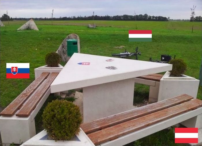
Sitting down at that table means you are technically having lunch in three countries simultaneously. Not much is publicly known about who decided to place a table here or exactly when, but the concept is genuinely brilliant. Whoever thought of it deserves some serious credit for creativity.
The Most Confusing City Border You Have Ever Seen: Belgium and The Netherlands at Baarle
If you enjoy puzzles, the border situation between Belgium and The Netherlands in the town of Baarle will absolutely fascinate you. The Flemish municipality of Baarle-Hertog is a piece of Belgian territory that is almost entirely surrounded by The Netherlands. And it does not stop there.
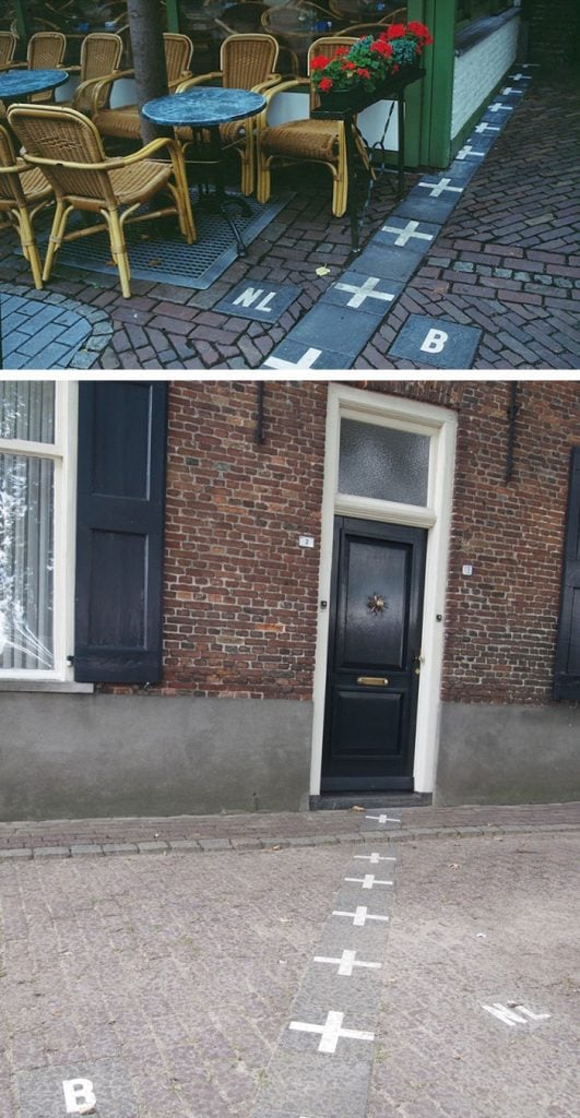
The border does not follow a clean line. It weaves through streets, cuts across houses, and creates a patchwork of Belgian and Dutch territory within the same municipality. Baarle-Hertog shares this border with the neighboring Dutch municipality of Baarle-Nassau. The result is a map that looks more like abstract art than a political boundary. This situation exists because of medieval treaties that were negotiated centuries ago, and nobody since has ever quite managed to untangle them.
Interestingly, some homes in Baarle sit right on the border, meaning the front door determines which country you officially live in. If a homeowner wanted to switch nationalities, historically they could simply move their front door. That is perhaps the most low-effort country change in human history.
The Country That Has No Land Borders With Anyone: Australia
This one is a bit of a joke, but it is also completely accurate. Australia does not share a single land border with any other country. The reason is straightforward: Australia is simultaneously a country and an entire continent. That combination means there are no neighbors to share a fence with.
That said, Australia does share maritime borders with several countries: New Zealand, Papua New Guinea, New Caledonia, Indonesia, and the Solomon Islands. That is quite a few neighbors with the word “new” in their name, which is a fun detail worth pointing out. Australia is, in border terms, the ultimate hermit of the world. Surrounded by ocean on all sides and perfectly content about it.
The Longest Border in the World: Canada and the USA
The border between Canada and the United States is not just famous. It is officially the longest international border in the world, stretching approximately 8,890 kilometers through land and water. Parts of it look eerily similar to the Norway-Sweden forested border, with a cleared line running through dense wilderness as far as the eye can see.
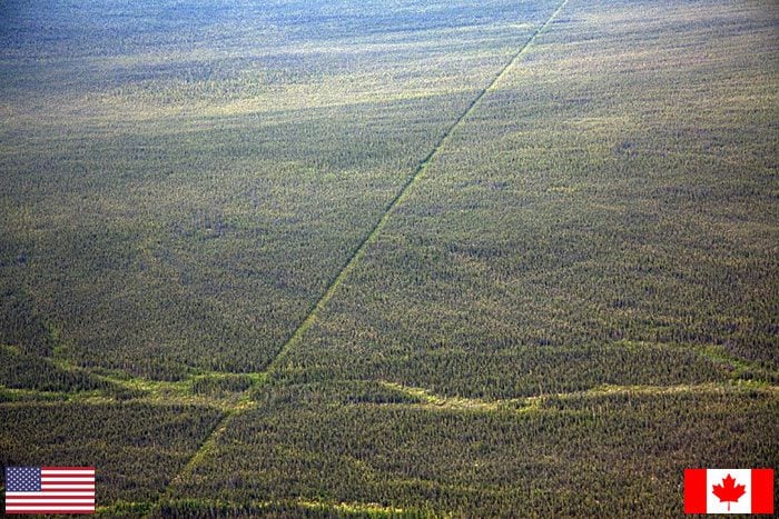
The border’s origins go back to 1783 and the end of the American War of Independence, settled by the Treaty of Paris. The current defined form of the border only came together in 1908 through a formal treaty between the USA and the United Kingdom. Over two centuries of negotiation, adjustment, and agreement to produce one very long line through the wilderness.
Three National Parks on One Mountain Peak: Poland, Slovakia, and Ukraine at Krzemieniec
Atop the Slovakian mountain of Krzemieniec, part of the Bieszczady mountain range in central-eastern Europe, stands a simple grey stone post. But that post marks something genuinely remarkable: the exact tripoint where Poland, Ukraine, and Slovakia all converge in one spot.
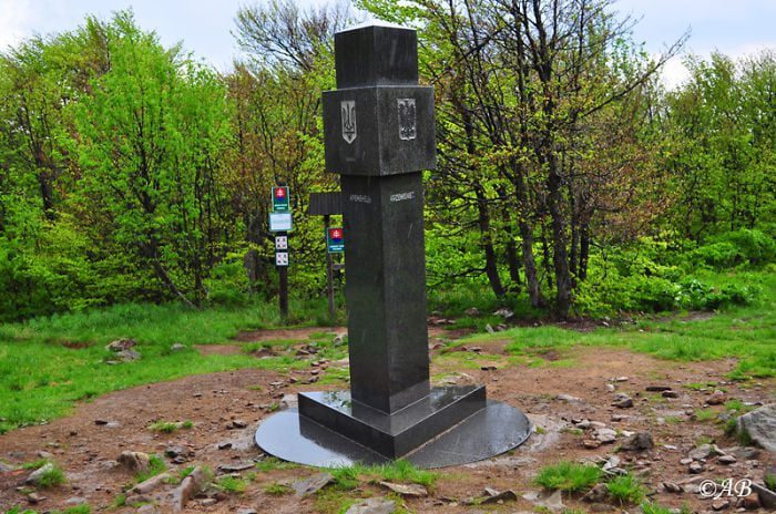
What makes this tripoint even more interesting is that three national parks, one from each country, also converge at this same peak. The UNESCO Stužica Reserve is here too. Detailed information about the marker and its builders is scarce, possibly due to language barriers, but the significance of that single grey post sitting at the top of a mountain is hard to overstate.
Two Castles Facing Each Other Across a River: Estonia and Russia at the Narva
In 1918, Estonia broke away from the Soviet Union and became the independent Republic of Estonia. With that independence came a border with Russia that runs for 294 kilometers. Most of that border is relatively straightforward, but there is one particular spot that stands out from all the rest.
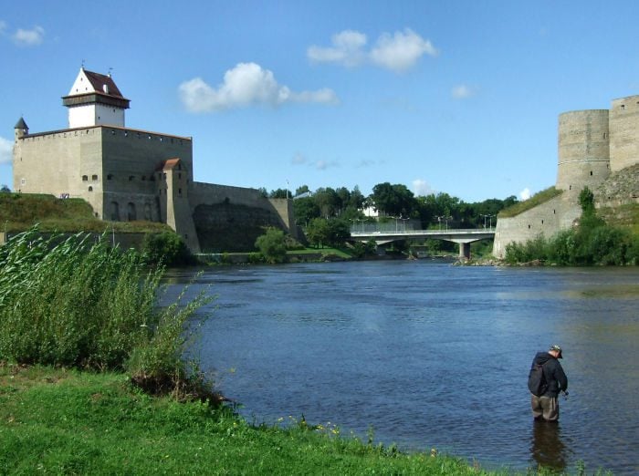
The Narva River forms a natural border at this section, with a bridge running over it. On either side of that bridge, two medieval castles stand guard. Hermann Castle watches over the Estonian side, while Ivangorod stands on the Russian side. Two ancient fortifications, built in different eras by different powers, now staring at each other across a river that separates two very different worlds. It is one of the more visually and historically dramatic border scenes on this entire list.
A River That Inspired Poets and Artists: Poland and Czechia’s Olza River
This aerial photograph of the Olza River is genuinely stunning. The river feeds into the River Oder and serves as the natural border between the Polish region of Cieszyn Silesia and the Czech districts of Karviná and Frýdek-Místek. Running for close to 100 kilometers, the Olza makes up part of the 796-kilometer Czech-Polish border.
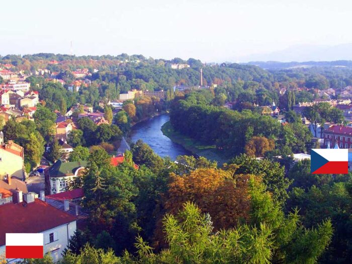
Beyond its role as a political boundary, the Olza has long been a source of creative inspiration for artists, poets, and writers from both countries. A river that literally separates two nations has somehow managed to bring their cultural imaginations together. That is a border doing something genuinely interesting.
A Waterfall Hiding Between Two Countries in Asia: China and Vietnam’s Ban Gioc Falls
Tucked between the Karst hills of Southeast and eastern Asia lies the Ban Gioc Falls, one of the world’s most spectacular waterfalls that most people have never heard of. The falls sit directly on the border between China and Vietnam, split between the Trùng Khánh district of Vietnam and Daxin County in China.
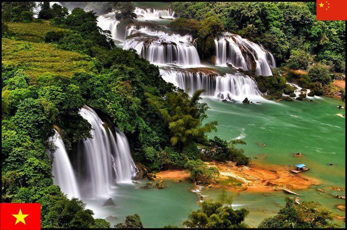
Ban Gioc holds the distinction of being the 4th largest waterfall situated along or between international borders. Depending on rainfall and river levels, the falls sometimes appear as one unified cascade and sometimes split into two separate falls. The area is also home to plant species found nowhere else on Earth. A border that doubles as a biodiversity hotspot is a rare thing indeed.
The Building That Belongs to Two Countries at the Same Time: The Haskell Library on the Canada-USA Border
In the spirit of unusual border arrangements, it is hard to top a library that simultaneously exists in two countries. The Haskell Free Library and Opera House is a Victorian-style building that was deliberately constructed on the border between Canada and the United States, specifically between the province of Quebec and the state of Vermont, in the towns of Stanstead and Derby Line respectively.
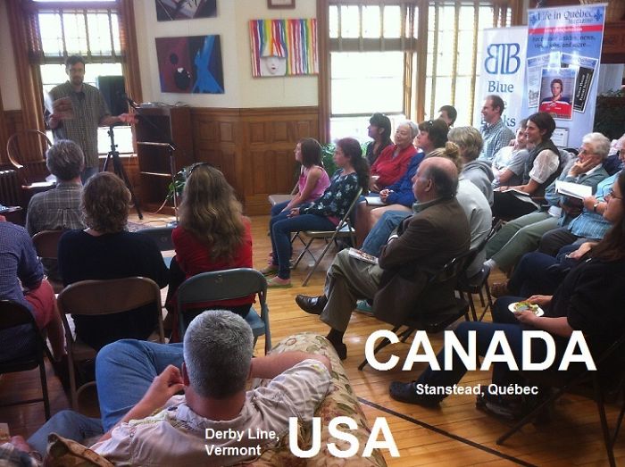
The Haskell building first opened its doors in 1904 and was recognized as a heritage site for both nations by the 1980s. Because it straddles the international boundary, the library has two official addresses. Its collection holds 20,000 books, making it not just a quirky border curiosity but a genuinely functioning institution. You could enter from the Canadian side, browse books, and walk out into the United States. Not many libraries can say that.
Three Rivers, One Border: Luxembourg and Germany
This picture most likely shows the Sûre River, known as the Sauer Fluss in German, which forms part of the border between Luxembourg and Germany. Here is where things get slightly confusing: the Sûre also flows through the Belgian province of Luxembourg. That is the province, not the country. Luxembourg the province and Luxembourg the country are two very different things that share the same name, which has confused countless travelers and geography students over the years.

The broader Luxembourg-Germany border is formed by three rivers: the Sûre, the Moselle, and the Our. All three rivers also flow within Belgian borders at various points. It is a hydrological web that ties together a small but historically rich corner of western Europe.
The Tiny Country Most People Have Never Heard Of: Andorra Between Spain and France
There is a very good chance that Andorra has never once come up in your daily life. That would be understandable. The Principality of Andorra is a small, landlocked sovereign state with an area of just 470 square kilometers, wedged between the borders of France and Spain along the Pyrenees mountain range.
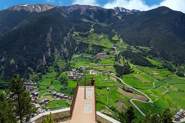
Andorra has a population of fewer than 80,000 people and Catalan Spanish is the official language. The country’s leadership structure is also genuinely unusual: Andorra is a co-principality, which means it always has two co-princes ruling simultaneously. Those two co-princes are always, without exception, the French president and the Spanish Bishop of Urgell. A French head of state and a Spanish Catholic bishop sharing power over a tiny mountain nation. That is a governance arrangement unlike anything else on the planet.
The Airport That Has to Use Another Country’s Airspace: Ukraine and Slovakia
In the western Ukrainian province of Zakarpattia lies the historic city of Uzhhorod, which shares a border with Slovakia. Uzhhorod is home to an international airport. Nothing unusual about that. What is unusual is that the airport sits just 90 meters from the Ukrainian-Slovak border.
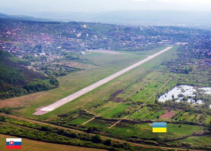
Because the airport is so close to the border, every single aircraft that takes off or lands at Uzhhorod International Airport must use Slovak airspace to do so. There is simply not enough Ukrainian airspace available for a standard approach or departure. This unusual arrangement is governed by special bilateral treaties between the two countries. It is a practical solution to a genuinely strange geographical problem, and it is the kind of detail that makes you appreciate how creative international diplomacy can get when it needs to be.
The Tiny Alpine Nation That Barely Appears on Most Maps: Liechtenstein Between Switzerland and Austria
Now that you know about Andorra, here is another microstate that deserves a moment of attention: Liechtenstein. The Principality of Liechtenstein is nestled deep in the Alps, bordered by Switzerland and Austria, with a total area of just 160 square kilometers. It is one of the smallest countries in the world and one of only two countries globally that is doubly landlocked, meaning it is surrounded entirely by other landlocked countries.
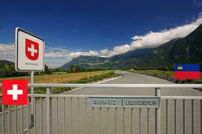
The Rhine River serves as the natural border between Switzerland and Liechtenstein and also provides a critical water source for the region. The state is a constitutional monarchy, currently represented by Prince Hans-Adam II of Liechtenstein. Despite its tiny size, Liechtenstein has a well-earned reputation for natural beauty and a surprisingly strong economy. Small does not always mean insignificant.
Europe’s Third Highest Paved Pass: France and Italy at Col Agnel
The Col Agnel mountain pass sits along the 515-kilometer border between France and Italy and reaches an elevation of 2,744 meters. That makes it the third highest paved mountain pass in Europe. The pass is connected to the Cottian Alps and is not exactly a household name, but it has some remarkable history attached to it.
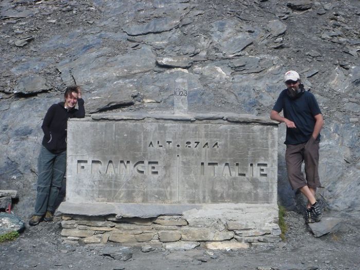
Some historians believe this pass was one of the routes used by Hannibal of Carthage during the Second Punic War, as he led his famous army (elephants included) across the Alps toward Rome. The theory remains unconfirmed, but the speculation alone makes it a pass worth knowing about. Today, Col Agnel is particularly popular with cycling enthusiasts who make the climb and pose beside the distinctive stone border marker at the top. Hannibal would probably have a very different opinion about the experience.
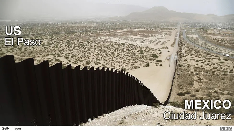
Where Two Countries Share a Volleyball Net: Mexico and the USA at Naco
The relationship between the USA and Mexico at the border tends to generate a lot of tense headlines. But here is a different kind of story from that same border. Naco is a tiny town in Cochise County, Arizona. Right next to it sits its sister city, Naco, in the Mexican state of Sonora. Both towns rest directly on the international boundary line.
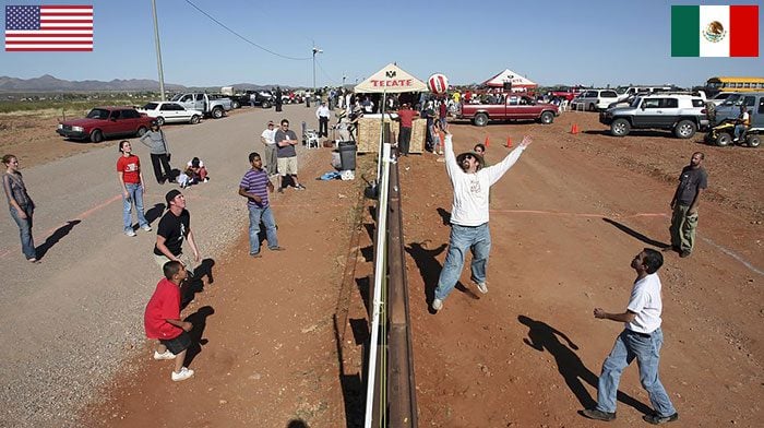
That shared placement seems to have created a genuinely warm relationship between the two communities. Residents on both sides of the border regularly get together to play volleyball, with the net literally serving as the international boundary line. The same fence that one side might call a barrier, both sides are using as a volleyball net. That is a perspective worth sitting with for a moment.
When Conservation Policy Becomes Visible From Space: Haiti and The Dominican Republic
The island of Hispaniola in the Caribbean Sea is divided between two nations: Haiti and the Dominican Republic. The Dominican Republic occupies the larger portion of the island. From the air or from a satellite, the contrast between the two sides is stark and deeply sobering.
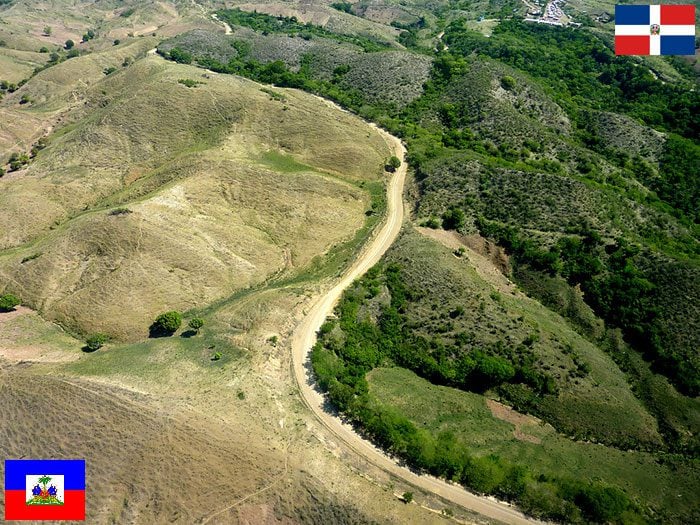
The most immediate thing you notice is the difference in greenery. One side is lush and forested. The other is largely stripped bare. This is a direct reflection of each country’s environmental protection policies, or the lack thereof. Haiti has historically had far weaker enforcement of forestry protections, and the satellite imagery makes those policy differences visible in a way that no amount of written explanation could match. It is a sobering image, and hopefully one that will look different as conditions improve.
The Myth of Zavikon Island: What People Get Wrong About Canada and the USA
Zavikon Island sits within the Thousand Islands archipelago on the St. Lawrence River. The name sometimes refers only to the larger of two nearby islands, and sometimes to both together, which is already a source of some confusion. But the bigger misconception is the popular story that Zavikon is shared between the USA and Canada.
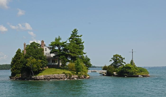
This is simply not true. Zavikon Island belongs entirely to Canada. The island is located within Canadian territory, and no part of it falls under American jurisdiction. Somehow, a story developed that claimed the small connecting bridge between the two islands was the world’s shortest international bridge. A charming tale, but an inaccurate one. Nobody is quite sure who started it. It has simply been repeated often enough that many people now believe it without question.
Two Neighbors, Two Very Different Choices: Brazil and Bolivia’s Deforestation Divide
Much like the Haiti and Dominican Republic comparison, this satellite image of the border between Brazil and Bolivia tells a story that numbers and reports alone cannot capture. The image, first taken in 2008, shows the contrast between Bolivia’s Pando Department and Brazil’s Acre province in terms of how each country uses its land.
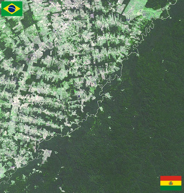
Brazil has historically had a far more aggressive approach to land conversion: clearing forestry to create farmland and cattle ranches. Bolivia has been comparatively less aggressive about this, and the difference is clearly visible from space. It is a satellite image that has become a powerful tool in environmental discussions, because the border between two countries literally shows you the consequences of different policy choices. Geography does not lie.
A Square That Changed Countries Multiple Times: Italy and Slovenia at Nova Gorica
Along the Italy-Slovenia border, you can find the Slovene railway station of Nova Gorica. The station is part of the municipal town of Nova Gorica and sits right on the border with the Italian city of Gorizia, which Slovenes historically call “old Gorica.” This particular stretch of border has one of the most complicated histories of any location on this list.
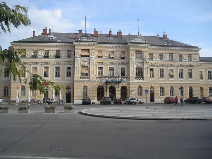
The Transalpina Square, which sits directly on the border between the two countries, has changed its name and its national identity multiple times over the years. Since the station was first completed by the Austrian Empire in 1906, this area has been reshaped by several wars, annexations, and treaties. It is the kind of place that carries the weight of European history in every stone.
Only a Street Apart: The Peace Border Between Brazil and Uruguay
Between the cities of Santana do Livramento in Brazil and Rivera in Uruguay, the border is about as relaxed and neighborly as international boundaries get. The two cities are separated by nothing more than a street. Just a single street. Because of their extraordinary closeness, they are widely regarded as a single international city shared by two nations.
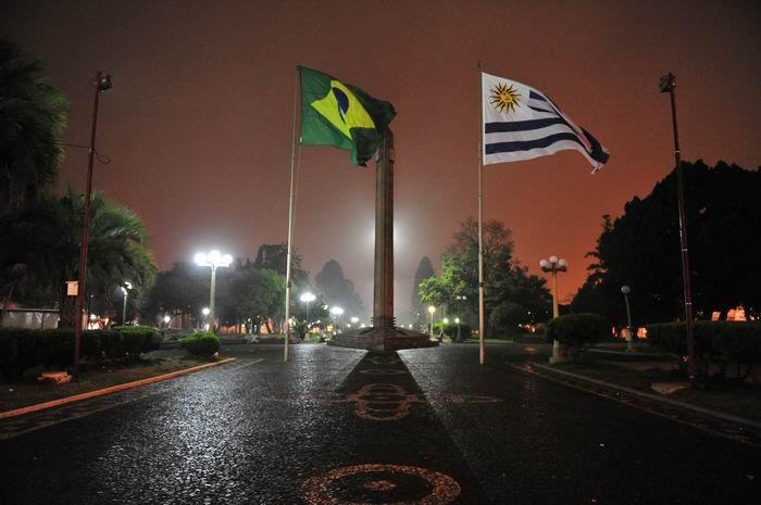
The border marker between them is called the Peace Border, marked by a tall obelisk placed within the International Square. The name says everything about the spirit of this particular boundary. This is not a line meant to divide. It is a symbol of two communities that have chosen to lean toward each other rather than away.
A 13-Meter Statue Built on a Mountain to Celebrate Peace: Argentina and Chile
High in the Principal Cordillera section of the Andean Mountains, at the point where Argentina and Chile share their border, stands a statue that is over 13 meters tall. This is Christ the Redeemer of the Andes, unveiled in 1904 as a symbol of friendship and peace between the two nations following a resolution to their border disputes.
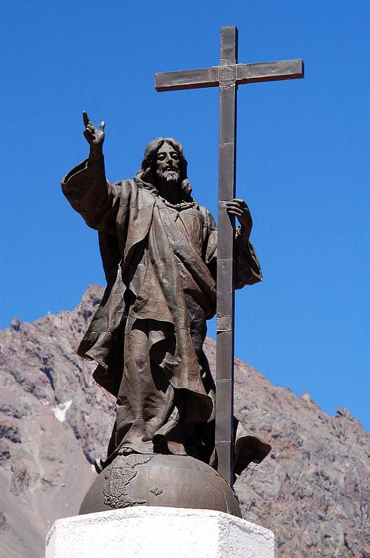
The statue can be seen along the old road that runs through the La Cumbre pass and has become a popular tourist attraction in its own right. Building a giant bronze statue at altitude on a mountain border as a peace gesture is a bold move. But it has clearly worked, as it still draws visitors over a century later.
How Britain Ended Up With a Border in Spain: Gibraltar
At first glance, the idea of a UK-Spain border sounds impossible. The British Isles do not share a land border with the Kingdom of Spain. That is true. But Gibraltar does, and Gibraltar is a British Overseas Territory.
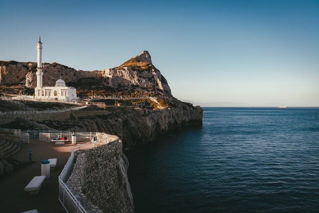
Gibraltar is a small territory located on the famous Rock of Gibraltar at the foot of the Iberian Peninsula. The area was originally part of Spain but was captured by British forces in 1704 during the War of Spanish Succession. It was formally ceded to the United Kingdom in 1713. Over 300 years later, Gibraltar is still British, still sitting right at the edge of Spain, and still a point of ongoing diplomatic discussion between the UK and Spain. The border crossing between Gibraltar and Spain is one of the more unusual entry points you will find anywhere in Europe.
A Waterfall Too Big for One Country to Own: Victoria Falls Between Zambia and Zimbabwe
Victoria Falls is one of the most powerful natural spectacles on Earth. Standing 108 meters tall with a width of 1,708 meters, it is one of the largest waterfalls in the world by sheer volume. And the international boundary between Zimbabwe and Zambia cuts directly through the middle of it.
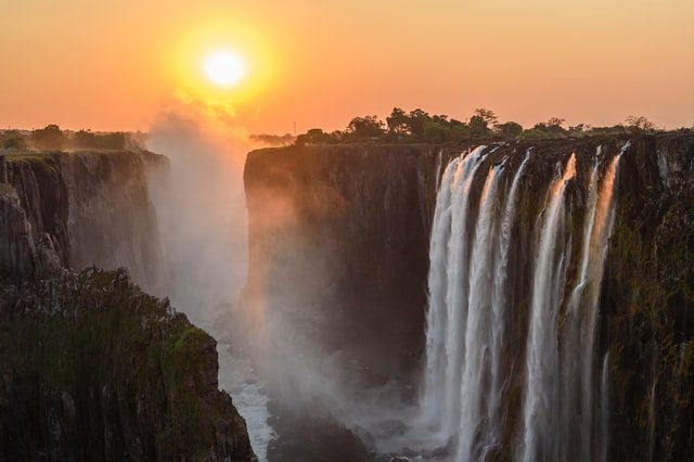
In the Tonga language, the falls are known as “Boiling Water.” In Lozi, they are called “The Smoke That Thunders.” Both names are entirely earned. Victoria Falls is a major tourist destination for both countries and generates significant economic activity for the surrounding region. It is perhaps the most dramatic natural border marker anywhere on the African continent.
A Rock Formation With a Sandstone Bridge Wedged Into It: Germany and Czechia at Bastei
High above the Elbe River, atop the Elbe Sandstone Mountains, sits one of Germany’s most visited natural landmarks. Bastei is a dramatic rock formation that has drawn visitors for centuries. The main attraction, however, is the sandstone bridge that was constructed in 1851, replacing older wooden structures that had stood there before it.

Bastei is primarily within German territory, but parts of the surrounding hiking and climbing areas extend into Czech borders. It is a reminder that natural landscapes do not always conform neatly to the lines politicians draw on maps. Sometimes a rock formation just refuses to stay in one country.
The World’s Smallest Country Hidden Inside Rome: Italy and the Vatican City
Most people have heard of Vatican City. Far fewer people actually know where it is or what it legally is. Vatican City is a fully sovereign city-state, an independent country in its own right, completely surrounded by Italy. It is the smallest country in the world both by area and population.
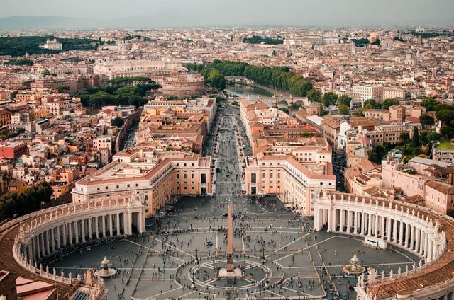
Vatican City was once simply part of Rome until the Lateran Treaty of 1929 established it as a separate sovereign entity. Today, the border between Italy and the Vatican is marked by the entry point of St. Peter’s Square, part of the larger St. Peter’s Basilica complex. Every year, millions of visitors walk across that border without even realizing they have stepped from one country into another.
When a State Governor Uses Shipping Containers as a Border Wall: The USA and Mexico in Arizona
The final entry on this list might be the most politically charged, but it is also one of the most visually striking. The US-Mexico border stretches across several states, and in Arizona, former Governor Doug Ducey took matters into his own hands by deploying old shipping containers along a section of the border that runs through densely forested natural land.
The containers are old and visibly rusted. They are double-stacked to increase height and topped with razor wire to deter crossing. The move was not without significant controversy. Environmental groups raised concerns about wildlife corridors and habitat disruption. Legal challenges followed. But the containers went up anyway, stretching for several miles through an area that was previously open forest.
Compared to the giant artistic fish marking the Poland-Ukraine border, or the volleyball net at Naco, the shipping container wall represents a very different philosophy about what a border should be and what it should say about the people on either side of it.
And that, perhaps, is the most interesting thing this entire tour has revealed. Every single border on this list reflects something true about the people who created it. Whether it is a peace statue on a mountain, a shared library that belongs to two nations, or old rusted metal stacked high with razor wire, a border is never just a line. It is a statement. The real question is: what kind of statement do you want to make?